KENNETH ARNOLD'S "JAGGED PEAK" AND LITTLE TAHOMA
Kenneth Arnold explained how, some 23 miles distant (Arnold measured it afterwards), an intervening "jagged peak" momentarily blocked his view of the nine, enigmatic aerial objects and that contributed to his calculations of distance, size and latterly, on landing at Pendleton Oregon, their apparently astonishing speed.
However, it later transpired that when asked to identify the peak on a map, he was unable to, as nothing seemed to match his account.
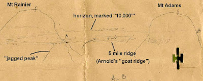
This is Kenneth Arnold's early sketch on a 'manilla' envelope - note that the horizon is marked "10,000" (feet) and 'goat ridge' also depicted (the descriptive text is not part of his original document).
 |
This is a 3D representation of same, on Google Earth, with Mt. Ranier, Little Tahoma goat ridge kand Mt. Adams all tagged.
Please 'zoom' into the image, for greater detail (might be preferable to download a copy first).
 |
This is a cropped and enlarged section from the original drawing, showing only Mt. Ranier and Arnold's 'jagged peak'.

This is a cropped and enlarged section from the Google Earth 3D image, highlighting both Mt. Ranier and Little Tahoma (elevation 11,138 feet), with yellow tag names..
It shows a perspective from the original 3D image - nothing has been altered, other than tilting the image, for a clearer 3D view. You can also 'zoom' into this for greater detail (again, might be preferable to download a copy first).

Naturally, anyone with online access to Google Earth, can verify the above for themselves.
Bruce Maccabee believes that Arnold must have been referring to Pyramid Peak and Martin Shough suggests Glacier Island. Both necessitate alleging errors of enormous magnitude by Kenneth Arnold and neither location even closely resembles Arnold's sketch.
This is a Google Earth 3D map pinpointing the locations of Pyramid Peak and Glacier Island, which are adjacent to each other.

How could either, shown at the bottom left of Mt. Rainier, conceivably ,be accordance with Kenneth Arnold's sketch, confirming that his ",jagged peak", existed to the right of Mt. Ranier?
Enhanced data is available if you 'zoom.in' and recommended that you download a copy of the images beforehand.
This is an enlargement.

To reiterate; do either Pyramid Peak or Glacier Island resemble Arnold's following illustration?

Or does the "jagged peak" of Little Tahoma?

Some years ago, in an attempt to clarify this geographical conundrum, I took the query to people with expert local knowledge.
David Basset, a mountaineer with vast experience of Mt. Rainier and surrounding peaks, responded: “The jagged peak you are referring to is clearly Little Tahoma. It is jagged because it is unglaciated and very steep. It rises from the base of Mt. Rainier on the East or Southeast side. You said the observation was taken from the west or southwest.
This might be troubling because it is on the other side of the mountain, but rest assured, Little Tahoma is the peak. It stands out, being much higher than any other mountain close to Rainier.
Located at Mt. Rainier National Park, Park Guide Chris Trotter, and Douglas Kraus, the Park Naturalist, confirmed: “The consensus from my co-workers is that the ‘jagged peak’ is Little Tahoma. This peak can be seen from many areas around the mountain".
It would consequently seem to be categorically evidenced that Little Tahoma (or Tacoma) is the only peak which matches Arnold’s description and it would have been visible from his location.
If we accept this there are fundamental repercussions.
Arnold relied on the apparent, momentary disappearance of the objects behind a far-off peak to establish the objects’ distance and consequently their airspeed. Arnold, flying more or less eastwards towards Mt. Rainier’s slopes, consistently and repeatedly told how the nine objects, travelling southwards, passed directly in front of him on the western slopes of Mt. Rainier. Little Tahoma, however is on the mountain’s far eastern side.
The obvious conclusion is that Arnold misperceived how those nine objects momentarily disappeared behind this remote peak. In fact, they absolutely must have passed in front of it.
Arnold said he could see the formation against the mountain slopes. The objects then momentarily disappeared, in turn, behind his depicted peak. Arnold was 23 miles or so from it, which gave him a size and distance estimate, for his subsequent over 1,000 mph calculation.
The objects could not have been visible against the slopes and then also momentarily, each lost from sight, as they flew behind Little Tahoma. It is not located between Arnold and Mt. Ranier, it is behind Mt. Ranier, although cold be mistaken for being in front, because it is a prominent peak and perhaps deceptive.
If affirmative, then the objects must have passed in front of Little Tahoma, at Arnold's stated altitude - which does equate - and Arnold deceived.
Consequently, his speed calculation must be fallacious and no reason to suspect the formation of nine were anything other than everyday artefacts.
© James Easton
August 2023
jeaston.blog@gmail.com
Comments
Post a Comment